Projects

Arterial Management Center Staff Augmentation
New Jersey Department of Transportation
Traffic Engineering & Intelligent Transportation Systems
The NJDOT Arterial Management Center (AMC) is a centralized location which NJDOT and consultant staff manage mobility and safety for NJDOT arterial roadways. The NJDOT AMC modernizes traffic operations through AI-powered adaptive signal control, real-time data analysis, and predictive analytics. This proactive system reduces congestion-related crashes, provides travel delay reductions, and minimizes maintenance through early identification of system errors. TechniQuest Corporation (TQC) supports the Atkins Realis Team and the NJDOT AMC with four (4) full-time staff reporting on-site to monitor and analyze real-time traffic conditions.
TQC’s role at the AMC includes monitoring real-time traffic conditions and the SCATS transportation interface system along specific New Jersey corridors. TQCs AMC Staff is responsible for monitoring the various adaptive traffic signal systems, detection systems, vehicle probe data, and other systems/platforms related to traffic signal performance. The TQC operations team focuses on the monitoring of traffic flow, signal performance, and reports on all incidents pertaining to the exact corridors. These operators also leverage the ATSPM platform to generate key performance metrics and conduct system analysis for NJDOT’s Adaptive Signal Control Technology (ASCT) corridors. TQCs on-site analysts recommend and implement signal timing adjustments when incidents occur and are affecting signal performance. The overall goal of these metrics and adjustments is gaining efficiency, reducing vehicle delays, balancing major/minor flows, managing queues, and improving overall throughput.
One common method implemented by TQC operations staff for reviewing signal performance in real-time is monitoring maximum and residual queue lengths. Increases in queue can occur from general variations in traffic flow, such as peak hour operations, or from reported incidents on the roadway, such as a crash or disabled vehicle. The operators monitoring traffic report these incidents. The TQC team works collaboratively with NJDOT and Atkins to recommend and implement signal timing revisions, such as increasing cycle length and/or green time at SCATS-assisted intersections when queues are formed to help reduce delay or adding “time-gain” to certain intersections so all phases can be served depending on the time of day.
Other metrics for assessing performance may include assessing detection recalls on minor roadways and the minimum/maximum green-time assignments. Incidents on major corridors may have more impact on cross-streets, and adjusting signal recalls to allocate the necessary green-time to minor streets is another mitigation option. TQCs team also analyze and process traffic data to identify trends, areas of congestion (reduced speed), and recommend actions for improvements.
TQCs operators also help monitor the health of the intersections by reporting system errors that can occur either with the detectors or other signal components. TQC AMC Operators are responsible for reporting the health status of traffic signal subsystems (hardware and software) on adaptive traffic signal system corridors to NJDOT Mobility Engineering and the AMC Managers regarding several items, including Vehicle Detection, Traffic Signal Communication, Traffic Signal Software Applications, and Intelligent Transportation Systems (ITS). TQCs operators are responsible for reporting and identifying when an intersection system goes offline. Reporting these occurrences quickly and accurately allows the NJDOT to configure/troubleshoot the equipment proactively.
Staff Augmentation services for the NJDOT Arterial Management Center (AMC) occur at the Trenton HQ of NJDOT.

Route 18 Traffic Signal Optimization Study
New Jersey Department of Transportation
Traffic Data Collection & Transportation Planning
TQC made it a point the inspection of the newly constructed road was flawless
Scope of Work: The project included various aspects of roadway design and intersection safety improvements
Modernization of Briarcliff-Peekskill Parkway Data Collection Program
New York State Department of Transportation
Traffic Data Collection & Planning
The New York State Department of Transportation (NYSDOT) is undertaking a Corridor Scoping Study for the Modernization of Briarcliff Peekskill Parkway (BPP) in Westchester County. The project study area encompassed a 7-mile corridor of the BPP from the intersection of the parkway with Route 9 in Crotonville in the north till the exit to Taconic State Parkway in the south. The focus of the project is on the 44 signalized and non-signalized intersections along the corridor as well as along the surrounding local and adjacent roads connecting the various residential neighborhoods to BPP.
Project Goals: TQCs goals for this project were to support the project team in establishing the existing traffic volumes along the corridor, including performance of a travel time and speed report along the corridor to assess congestion and safety.
Scope of Work: Per the scope of services, the NYSDOT and WSP requested Turning Movement Counts and Classifications; Volume Counts ATR’s including Vehicle Classification Counts (tube counters, MioVision camera, video/high-resolution cameras, or other methods); Vehicle Queue Length determination; using MioVision Camera or similar, high-resolution video for capturing existing traffic congestion during the specific peak hours for both weekday and Saturday, and Video Footage for Safety Analytics Platform for up to 100 hours per six (6) specified locations.
TQC conducted Intersection TMCs at 44 locations, completed six (6) MioVision Queue Studies and installed ATRs at over 50 locations along Route 9A and the parrel/adjacent intersection roadways.
TQC also installed five (5) Iteris BlueTOAD® BlueARGUSTM Travel-Time-Based Performance Units and Software along the corridor to assess overall corridor performance. The BlueTOAD units and software include both real-time features, along with reporting features, to deliver a comprehensive view of travel times, speeds, congestion and OD Analysis. These units are installed and spaced approximately 1.5 to 2.0 miles apart to assess corridor performance and were installed for 14-days, covering two (2) weekends, to obtain a large sample of data along the corridor.
TQC deliverables for the project included:
-
Vehicle Turning Movement Counts. Manual Turning Movement Counts (TMCs) and Video Data Collection of 44 Signalized and non-signalized Intersections along the corridor and adjacent roadways. MioVision Data Processing included vehicular and pedestrian traffic volumes. Deliverables included Data Collected in Excel, PDF and MioVision Datalink Formats.
-
Average Daily Traffic. In-Road and Roadside ATR’s (including Radar, Video, Vehicle Classification Counts and Speed Monitoring) at up to 50 locations. TQC team processed and delivered all MioVision, MetroCount and Jamar Technologies Data Collected in Excel, JAMAR, PetraPro, and PDF formats.
-
Queue delay. Vehicle Queue Length and Control Delay determination; using MioVision Camera or similar, high-resolution video at 6 locations. TQC provided RAW video footage for all locations.
-
Travel Times, Queue Delay and Speed Studies. Corridor-wide Travel Time, Speed and Congestion Monitoring capturing existing traffic congestion over a 14-day period using Iteris BlueTOAD Equipment and Tru-Traffic Vehicle Probe Data.

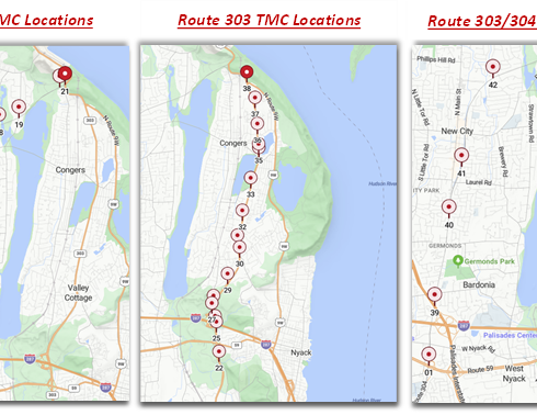
Clarkstown Route 303/304 Safety & Sustainability Study
TOWN OF CLARKSTOWN
Traffic Data Collection
The Town of Clarkstown Sustainability Study for Routes 303 & 304 will examine ways in which to increase safety and efficiency for motorists and pedestrians along the entire length of both roadways and will be extensions of, and modeled from, the Orangetown Sustainable Development Study of Route 303, which was funded by NYMTC.
Project Goals: TQCs goals for this project were to support the project team in establish the existing multi-modal traffic volumes along the corridor, including bicycle traffic at State Route gateways, to support the determination of future improvements to Route 303 and Route 304.
Scope of Work: TQC conducted Intersection TMCs at 37 locations and installed ATRs at 12 locations along to parallel corridors. This includes 21 Intersections along NYS Route 304 and 16 locations along NYS Route 303. ATR Data collection included all ramps at the interchanges of Route 303 and Route 304 with Route 59 in West Nyack. These are depicted as ATR Locations #01 and #23 within the inset maps.
TQC data collection efforts also included 48-hour cyclist counts at three (3) locations along Route 304 on a Saturday and Sunday to support the project goal of establishing existing bicycle traffic which diverts from Route 303 due to no existing facilities.
TQCs overall scope of work included the following:
-
Prepare Traffic Data Collection Plan and Quality Control Sheets
-
Deploy, Monitor and Remove MioVision and JAMAR Traffic Data Collection Equipment
-
Process, Quality Control and Deliver Intersection TMC, 48-Hour Bicycle and 7-Day ATR Data
Grand Central Terminal Train Shed Rehabilitation
NYCDOT / MTA
Traffic Data Collection
Project Goal: TQC supported Dewberry Engineers in the completion of traffic data collection and traffic engineering analysis within the Grand Central Terminal. The goal of TQCs efforts is providing traffic data to support the preparation of an Environmental Impact Assessment and Technical Memorandum describing the screening process for the review and approval of NYCDOT. All traffic data collection was required to be completed per the requirements of the NYCDOT CEQR Manual.
Scope of Work: TQC scope includes collecting data at 30 signalized intersections within Manhattan Borough between 45th Street and 58th Street along Lexington Avenue, Park Avenue and Madison Avenue. The efforts also included installing ATRs at 8 locations and performing pedestrian traffic studies at 10 locations. TQC staff also completed field inventory of all intersections, reviewed parking demand and capacity at 78 parking garages and completed
The completion of the data collection effort required coordination with NYCDOT, including the completion of a NYCDOT Camera Deployment Request. This request outlined all scheduled data collection locations and equipment and was also submitted for review and approval by the Grand Central Partnership.
TQC completed traffic data collection over a 10-day time period in December of 2023, and then repeated the same effort in June of 2024. The goal of this effort was to establish a comparative analysis of traffic data, as well as establish sufficient dates/times to satisfy NYCDOT CEQR requirements.
TQC staff also performed travel time and delay studies along Madison Avenue, Park Avenue and Lexington Avenue. Travel time and delay runs will also be collected using the “floating car technique” in which the survey car travels at the prevailing speed of the traffic stream. This method requires a driver and data recorder in each car to record the travel data through each of the air quality analysis sites during the same time as the traffic counts are collected. A total of two vehicles would be used to collect the required six to nine runs per link for each analysis hour.


Passaic County Regional Traffic Signal Optimization
Passiac County
Traffic Data Collection
The Passaic County Regional Traffic Signal Optimization project was a federally funded CMAQ program aimed to reduce congestion, vehicle emissions and increase safety. The project encompasses a 15-mile corridor with over sixty traffic signals. TQC teamed with Colliers Engineering and Design to collect traffic data, develop improved timing schemes, and propose recommendations for signal upgrades and improved safety.
Project Goals: The goal of the project was to optimize traffic signal operation throughout the entire corridor or within clusters of the corridor. TQC objective within this goal was to develop a program to collect traffic data at all signalized intersections along the corridor (as well as key adjacent intersections) and establish baseline conditions for signal optimization.
Scope of Work: TQC developed an approach to collect TMC data in clusters over a one-month period. This method was necessary as the overall scope includes eighty-one total intersections, sixty-six along the primary corridor. The schedule developed enabled the teams to collect data in four clusters based on existing and anticipated signal coordination and is included below as a reference.
TQC staff also performed baseline travel time studies for three weekdays and one weekend for the corridor which were utilized to assess corridor synchronization. The travel time studies completed will also serve as the before condition of the “Before and After Study.” TQC will complete the “After” travel time runs following the implementation of updated signal timings by Passaic County.
The scope of work included field inventory, traffic data collection, travel time analysis and crash data analysis. TQC staff supported the project by completing the following tasks:
-
Deployment, Monitoring and Processing of 81 Turning Movement Counts using MioVision Scout Video Detection Equipment.
-
Bidirectional, 24-hour ATR counts for a 10-day period to record volume and classification data at 11 sites (22 total ATRs).
-
TQC completed the Travel Time and Delay Studies via Tru-Traffic Software using the floating car method.
-
TQC reviewed, prepared crash summaries and crash diagrams for all sixty-six signalized intersections within the corridor.
Middlesex County As-Built Traffic Signal Certifications
MIDDLESEX COUNTY
Traffic Engineering
TechniQuest Corporation (TQC) supported Middlesex County in the completion of the 2022 and 2023 Roadway Milling and Paving Contract. This contract encompasses various locations throughout the County. The Contract specifications require the contractor to complete Traffic Signal System Certification as part of this contract. The specifications state the contractor’s engineer shall inspect the traffic signal for conformance with the authorized traffic signal plan (LTS plan), MUTCD and ADA Regulations. TQC served as the contractor’s engineer for this contract for the past two years (2022, 2023 & 2024).
Project Goals: TQC provided Traffic Engineering Certification & As Built Plan Services for Various Roadways in Middlesex County. TQC supported As-Built Traffic Signal Certification for the 2022, 2023 and 2024 Middlesex County Roadway Milling and Paving Contract. TQCs role in this contract is to review complete a review of as-built conditions prior to construction and following the construction of intersection improvements, specifically installation of HD Video Detection
• 2022: TQC reviewed 43 signalized intersections within the scope of work and prepared as-built traffic signal and electrical design plans are the required at 8 intersections within the project limits.
• 2023: TQC reviewed 12 signalized intersections within the scope of work and prepared as-built traffic signal and electrical design plans are the required at 9 intersections within the project limits.
• 2023: TQC reviewed 8 signalized intersections within the scope of work and prepared as-built traffic signal and electrical design plans are the required at 3 intersections within the project limits.
Scope of Work: TQC services included performing conformance inspections for traffic signals within the project limits. The conformance inspections of TOC determine the signal improvements have been constructed in accordance with the "Authorized Traffic Signal Plan (ITS)," as well as all national standards. TQC scope of work required the design team prepare and submit to Middlesex County, on behalf of the Contractor, a certified signal plan, electrical plan and engineering certification signed and sealed by an NJ Licensed Engineer. The certification should note any deviations from the LTS or national standards. The final deliverables include a certified Traffic Signal Plan printed on mylar, traffic signal timing and signed/sealed Engineer Certification. As-Built Plans are prepared using Bentley MicroStation per NJDOT CADD standards. TQC performed all work and provided all deliverables in accordance with the standards of NJDOT, MUTCD, and Middlesex County, as noted in Section 702.03.14 of the Specifications.
The following is a detailed description of TQCs scope of work as the contractor’s engineer.
-
Field Inventory. Completed on-site review of Middlesex County current as-built traffic signal and electrical plans. TQC field inventory included verifying and updating the plans to current conditions. Intersection signing, striping, pavement markings and above-ground signal equipment were verified/updated as necessary. TQC also verified electrical wiring design and updates the plans to reflect signal upgrades to detection implemented as part of the Milling and Paving Contracts.
-
As-Built Signal Design. Completed Signal/Electrical Design of signal upgrades, specifically revisions to wiring to accommodate revised detection systems and perform CAD Drafting to provide all deliverables in accordance with the standards of NJDOT and Middlesex County.
-
Quality Assurance and Control. Prepared PDF Plans of red-line as-built markups and photo log of all locations for documenting plan changes as part of the as-built plan process.


SJTPO
Local Road Safety Program
SOUTH JERSET TRANSPORTAITON PLANNING ORGANIZATION
GIS Data Collection & Field Inventory
TQC supported SJTPO and GPI in the development and implementation of the Countywide Local Road Safety Plans. This was a planning level effort intended to address the unique safety needs under county and local jurisdictions, while also identifying improvements which are consistent with the New Jersey 2020 Strategic Highway Safety Plan. TQC supported the project planning by conducting the review of County Roadway Facilities and developing roadway attribute data.
Project Goals: TQC Scope of Work was focused on completing a review of the 10,000 County Facility Roadway Segments. These were broken into two categories. Priority 1 being the highest priority roadway segments which shall be addressed throughout the SJTPO Region. These priority roadway segments encompassed approximately 1,100 segments which will be addressed in the initial planning process. Priority 2 encompassed all remaining roadway segments to be addressed throughout the SJTPO Region.
Scope of Work: TQC engineering task for this project is the review of County Roadway Facilities characteristics and attributes identified as part of the NJDOT Straight Line Diagram database. TQC reviewed the County Roadway Facilities segments within the SJTPO region, evaluating the existing data, verifying and/or updating the attributes of the roadway and inputting accurate data within the ArcGIS database which will support the Data Analysis phase of the project.
TQCs task on this project was the review of the following roadway attributes: (1) Posted Speed; (2) Number of Lanes; (3) Shoulder Width; (4) Median Type; (5) Shoulder Type; (6) Fixed Object Offset and (7) Roadway Lighting
